
Coxe Summary of Court Trials


This research has been compiled by Michael F. Brinkash, a Professional Land Surveyor for educational purposes and is not intended for legal means or purposes. Any and all legal reference material included herein should be consulted with an attorney should there be a need for such advice.

Partial Summary of the Case Presented Before the Court of Common Pleas of Schuylkill County, No. 795, March Term 1875
Eckley B Coxe, Charlemayne Tower and others (Plaintiffs)
vs.
Daniel Shepp, Nelson Brandon and Daniel Bitler (Defendants)
Pershing JP – Gentlemen of the Jury: This is an action of ejectment brought by the plaintiffs to recover the possession of 193 acres and 74 perches of land situate in East Union Township, Schuylkill County, being a part of a tract of land surveyed on a warrant dated 13th day of June 1793 to John Davidson, which land of the defendants in their pleas admit to be in their possession.
In support of their title the plaintiffs have given in evidence the application of John Swayne and others on the 13th of June 1793 for 131 tracts of land, including the John Davidson tract. They follow this by a warrant to John Davidson of the same date for 400 acres described as adjoining lands granted the same to James Smith; also a survey made October 7th 1793 by William Gray and Deputy Surveyor of 400 acres and allowance bounded on the South by the Peter Swartz survey, on the East by Paul Beatty, on the North by the Michael Smith and on the West by the George Langs, James Smith and Richard Shearer surveys. The survey of the John Davidson calls for a pine at the northwest corner, a white pine at the northeast corner, a white oak at the southwest corner, and a white oak at the southeast corner.
It appears from the evidence that this tract of land passed by deed dated 31st of December, 1794 to Tench Coxe: that a patent was issued on May 17th, 1830 by the Commonwealth to Charles S. Coxe in trust for the other Coxe Heirs, and the title thus granted by the Commonwealth has been traced down to the plaintiffs in this action.
In connection with this, the plaintiff’s also offered warrants and surveys in evidence of the Paul Beatty, Peter Swartz and other tracts, with a connected draft of ten tracts showing their location. This they followed with evidence of the assessment of this John Davidson tract and payment of taxes upon it from 1819, the earliest date, it is said, at which it could be assessed in this County down to 1875, the date of the bringing of this suit. They supplemented this with the evidence of a number of surveyors, for the purpose of showing the location of the John Davidson tract upon the ground.
The defendants, in reply to the prime facie case of the plaintiff’s, gave in evidence the application of George Moore and 45 others, also dated on the 13th of June 1793, and it followed it by warrants and surveyors made by William Gray the Deputy Surveyor, and in connection therewith a connected draft showing the location of 19 tracts. The defendant’s, you will observe, rest their defense in this case in the first instance on their title to the Peter Swartz tract, one of the tracts included in the application given in evidence by them. The survey for this Peter Swartz tract was made on the 14th day of October, 1793, and the calls for adjoiners are Thomas Davidson on the South, the John Davidson on the North, the Roger Beatty on the East and the Richard Shearer and Joseph Evans on the West. The official draft of the Peter Swartz shows a white oak at the northwest corner, a white oak at the northeast corner both common to the Swartz and the John Davidson, a birch tree at the southwest corner, and an ash at the southeast corner.
In further tracing their title to the land in controversy, which does not include the whole of the John Davidson tract or survey as claimed by the plaintiffs, the defendants offered in evidence the fact that the Peter Swartz tract was sold by Andrew Albright, Sheriff of Northumberland County, for non-payment of taxes, and was purchased by Philip Meyer, who received a deed for it on the 30th of October, 1806. This was followed by an agreement dated 26th of November, 1807 by which Philip Myer conveyed or agreed to convey to William Gotchall and Peter Swartz and Roger Beatty tracts of land, together with a deed dated 20th of February 1808 by Philip Meyer and wife to William Gotchall for the Swartz tract which is described as adjoining lands of Henry Miller and Philip Myer, containing 400 acres and allowance. Also a deed dated 15th of May 1820 by which William Gotchall conveyed to Gould Phinney a part of the Swartz tract, described as beginning at a white oak marked for a corner, then describing it by courses and distances, bounded by land of Peter Knabb, Thomas Gotchall, Peter Keely, by William Gotchall’s other land, and by the Roger Beatty tract to the white oak, the place of beginning, containing 183 acres and 114 perches. It is this amount of land which the defendants claim that they have the right to hold in this controversy.
On the 26th of March, 1830, as appears further evidence of the defendants, Gould Phinney and his wife conveyed to John DeFrehn and William Gotchall this same tract by the same description, reciting a paten to Tench Coxe before alluded to in the connection of the title of the John Davidson survey; also reciting a release from Charles Coxe and others for his interest Peter Swartz to Gould Phinney, dated 28th of December 1829, on which day it appears Gould Phinney had conveyed to Coxe the John Davidson tract in consequence of having purchased it in 1822 at the Treasurer’s sale. The defendants also offered judgements entered by Phinney against the purchasers, DeFrehn and Gotchall for the purchase money. It appears the first of these judgements was not paid, because the execution was issued 1831, the year after Phinney conveyed to Gotchall and DeFrehn, and upon that levy was made upon this same tract, bounded by lands of Jonas Buck, Peter Knabb, Michael Lorah and others, containing 183 acres more or less, with the appurtenances consisting of two log dwelling houses, one log barn and one log stable. This land was purchased at the Sheriff’s sale by Louis Audenreid who received a deed therefore, and then mortgaged it to Thomas and William Hart, who proceeded to foreclose the mortgage, obtained a judgement against Audenreid and the property was sold upon this judgement by the Sheriff and would be evidence of the location of the other.
The plaintiffs here disclaim any right to the recovery or occupancy or ownership of any part of the Peter Swartz survey, so the defendants deny any right of ownership at this stage of the action, so far as the original location is concerned, to any portion of the John Davidson. Their claim to any portion of the John Davidson is under the statute of limitations, and not growing out of the original paper title derived from the Commonwealth and traced down to the respective parties.
The first important question for your consideration is one of location. Where was the John Davidson tract? Located? Where was the Peter Swartz tract located? Upon this question a great amount of evidence has been laid before you. Quite a large number of surveyors on both sides have testified in regard to the location of these tracts. As this is a material question in this case, although I have no doubt you desire the Court to be as brief as possible, yet in this discharge of the duty which devolves upon us we feel constrained to call your attention as rapidly as possible to the material facts bearing upon location.
The above Information is only a very small snapshot of the numerous courts records. The Court of Common Pleas of Schuylkill County ruled in favor of the Plaintiffs for 193 acres as a part of the John Davidson Warrant, on March 23, 1882. The Defendants appealed the decision of the Court of Common Pleas of Schuylkill County to the Supreme Court of Pennsylvania, Eastern District:
No. 38 January Term, 1892
Daniel Shepp and James J. Dull (Appellants)
vs.
Eckley B. Coxe, Executor and Guardian, et. al.; Charlemagne Tower, Jr., Richard Henry Lee and Julius A. Bailey, Executors of C. Tower, deceased, (Appellees)
The trail started Monday, December 8th, 1890 and concluded Friday, April 3rd, 1891, lasting a total of 91 days.
On appeal: Third. The assignment of error are based on the question as to the location of the dividing line between the Peter Swartz and John Davidson Surveys, Appellants had eight surveyors, whose combined testimony covers 2614 type-written pages, and on that part of Appellees, nine surveyors, (not including the field notes of six deceased surveyors, about 241 pages), whose combined testimony covers 958 type-written pages.
Fourth. Eight surveyors called by the Appellants, testified at length as to the location of the Swartz and Davidson surveys and the dividing line between them.

Fifth. The testimony of George Stauffer, covers in the record 779 pages and only 10 pages of his testimony in chief have been printed and not one word of his cross-examination which was contradictory of his examination in chief.
There appears to have been a total of 17 surveyors testifying at the trial held at the Court of Common Pleas, not including the field notes of 6 deceased surveyors were accepted as evidence.
The higher court appears to have upheld the verdict of the lower court.
It is believed that the stones were made by a local stone cutter and placed by surveyors subsequent to either the first trial or second trial. These actions are also assumed to have been taken by the case winning Plaintiffs. Some records were found to exist at the office of the former Butler Enterprises in Hazleton, no longer in business and location of records cannot be found. The first Butler Enterprise record is an enlargement of the southwest corner of the John Davidson Tract (page 318, old record) and showing two set stones dated 1793, one located on the westerly line, at 558 of this tract and the other is at 525 at the southwest corner. Similar set stones (red) are called for at the southwest and southeast corners, and a set stone marked 1793 is also called for at the northwest corner.


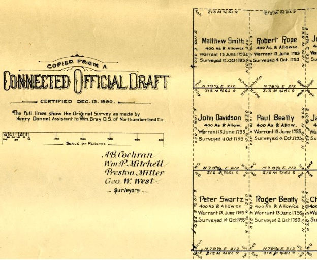
The following is a partial clip of a larger Connected Warrant Map, including the John Davidson tract, certified to by several surveyors whose names are shown in about in the center of the clip. At the first trial A.B. Cochran was the first surveyor to testify on behalf of the plaintiffs. Three of the four surveyors listed on this map can be verified as testifying at the first trial. Surveyor Mitchell may have testified, however; he is the only one I cannot verify as presenting testimony. The larger map from which this clip came from is located at the National Archives and Records Administration, Washington, D.C. Certified December 13, 1890.
The top of the set stone is approximately 8 inch square and the total length is unknown. The 1793 represents the year of the John Davidson Warrant. It is also worthy of mention that the Davidson Warrant is one of 131 warrants issued in this geographic area in 1793. These stones were set in the latter part of 1800’s and subsequent to either one of two trials as previously described above. As shown on the former survey map of the John Davidson Warrant at least two of the set stones are called “red” set stones. Land Surveyors of today call these set stones “brown stones”.

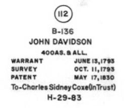
The following is a copy of the John Davidson Warrant, as shown on the Original Draft, of the Connected Warrantee Township Map; for Union, North Union and East Union Townships, Schuylkill County. This map is filed in the Division of Land Records of the Pennsylvania State Archives located in the Museum Building.

As stated in the court records: Praecipe for Habere Facias Possessionem: For all tract or piece of land situate in East Union Township, Schuylkill County, Pennsylvania, beginning at a stone heap in the eastern line of the John Davidson tract, thence south 82 ¾ degrees west 201 perches, thence by James Smith tract south 7 ½ degrees east 154 perches; thence north 82 ¾ degrees east 201 perches, thence by the Paul Beatty tract north 7 ¼ degrees west 154 perches to the place of beginning; Containing 193 acres and 74 perches and “being a part of a tract” or piece of land, surveyed on a warrant granted by the Commonwealth of Pennsylvania to John Davidson, dated 13th June 1793.





Comments